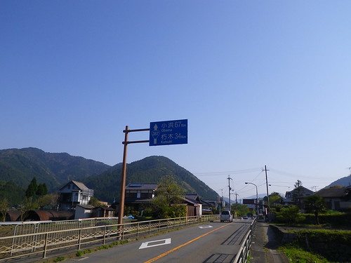
I set out on the first bus of the morning that leaves Demachiyanagi at 6:59 and gets to the Ohara bus terminal at 7:30. I had meant to get off at the Family Mart and get some food, but realized I only had 200 yen in coins and a 5,000 yen note in my wallet. I rode to the end and got off last so I could ask the bus driver what I should do. "Well, I can't make change so just put in the coins you have." "I'm so sorry." "Don't worry about it."
So I backtracked south to the Family Mart. Ohara is much better in the early morning with people tending to their fields and old men willing to offer a hearty "Ohayo." To my surprise the Family Mart was packed, not with hikers as I had feared, but with drivers. Families with chubby wives and disobedient children lined up for the bathrooms while the husbands bought cigarettes and sandwiches and had greasy hair and leather jackets. While I enjoy driving places I resent people who get to places by cars while I am hiking. I am an elitist. Maybe I am a purist. Maybe I am a separatist. What does it portend when I am walking the road to Obama?
There are several trails leading to the east out of Ohara. I wanted to take the one that lead up around Otonashi Falls, where I had gone the week previously. The first thing I noticed is that the flowers were gone.

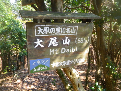
At 8 in the morning, my trip to the Family Mart and back having cost me 3o minutes or so, there are few people around. Some from the area setting up their shops, some from the first bus getting an early start although the temple don't open until later. The morning was cool and I quickly passed Otonashi Falls and all signs of people in about 20 minutes. From there the going got a little rough. It had been raining earlier in the week and the ground around the stream was pretty mushy. For several reasons, not the least of which being a giant hole in my hiking boot, I have been hiking in running shoes lately. It is a strategic decision, but it didn't serve me well for the first part of this hike. The trail is poorly marked and often not a trail but a hunch as to which way looks more passable. There is a stream, and following it will get you there, but everything was very wet and sloshy. I ended up crawling under fallen trees and sliding in a controlled fall down an embankment. I also lost my Bama ball cap. I will think of it as an offering to the mountain. After about 30-45 minutes the trail gets steeper and slightly easier to recognize. However I would say that this is not a hike to do if you tend to get panicky about being lost in the woods or have bad instincts about which way to go. I had a compass and a good map and have a moderate idea about what I am doing. It was still a little daunting and slightly bear-tastic. I didn't have a bell so I clapped periodically. The stream separates further up the mountain. Both branches look like trails, but there are some red markers to the right. Believe them. From here it is a straight up hike up the mountain. It is rather steep, but pleasant and the views back down to Ohara are incredible. When you finally do reach the top of this mountain called Daio on the map and Daibi on the sign, you are stricken by the fact that you are looking down at Lake Biwa. I wasn't carrying my camera, but rather Natsuki's tiny, water-proof, death-proof one. I didn't trust it to take in scenery and wasn't sure with how it operates so I took this.
Fairly insufficient. Here the trail devides north and south. North is not on the map. South is and was the way I was headed. Soon the trail parallels an unpaved country road. It also gets vague again. It tells you to vear into the woods and then leads you back onto the road. I don't mind walking a country road in the mountains so if the trail is the road tell me to take it. But out of fear of losing the trail I kept hopping back into the woods and then out of them again. Small creatures in the underbrush hopped as well. My advice to future travelers is: Just walk on the damned road. When the trail starts up another incline it is obvious. At this junction I met an old man, the first person I had seen in a few hours. He told me that both the road and the trail go to Hieizan. "The road is quicker..." He offered. "I'll take the trail." I said, and he smiled in approval. The woods were great, not too thick but not too thin. A lot of tall tress with slight underbrush. To the left is Biwako to the right is Ohara. The views aren't panoramic but the bits that you can sneak through the forest are tantalizing. It was in this area that I found fresh inoshishi tracks.

If you are thinking, "Cute, a wild pig." Then you are neither from the south or rural Japan. These things are little death tanks with a yearning to yank out leg arteries. Stay away. I started scouting for trees to scurry up.
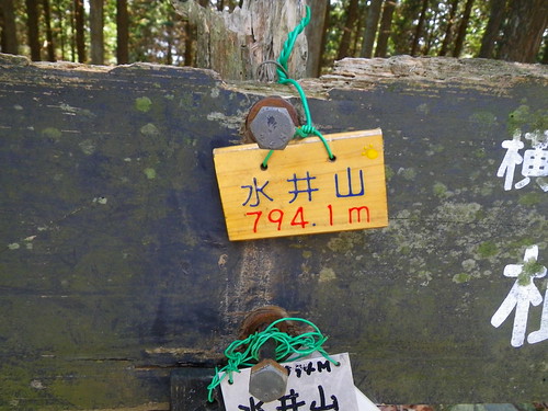
After passing the summit of Mt. Ono, the trail descends to Ogitake. I believe that is the correct reading. You will find that often on trails in Japan, the readings on signs and maps disagree. This is where the trail merges with the larger Kyoto Ishyu Trail, which is better marked and maintained. The trail that leaves from in front of the Family Mart also intersects here. I sat down and ate a smushed Tuna sandwich that I knew would be smushed by the time I ate it.Somewhere on this part of the mountain the trail separates strangely. One branch goes off towards the Shigaken side, one continues up to mount Mizuii. Strangely the two branches run alongside each other for a bit and I played it to safe and went off to the right on a marked trail that isn't on the map and doesn't go where I needed it to go. Be careful. Just because it has red markers, doesn't mean it is the real trail. At this section, the real trail looks like a well maintained trail. Stick to that.
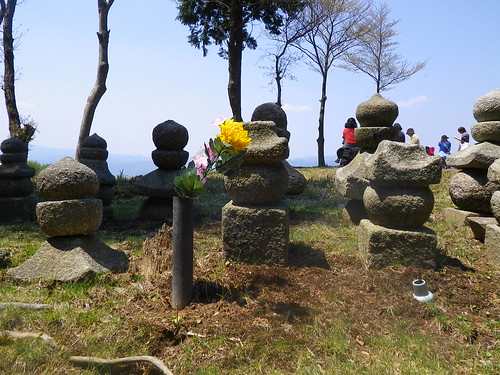
And then there was the summit of Mizuii, which is rather Blair Witchy and is strewn with small stones. A large crow came screeching around the clearing. Through the woods you can look back at the Ohara valley. I had run out of Ulon-cha and was on to water at this point.
Pat II : Updated
Paul Theroux, one of my absolute favorites, describes a kayaking trip he took by saying "I wanted to go to my view." That was very much in my mind on this trip. As anyone who has been to Kyoto knows, part of the beauty of the city are the mountains that protect it. Hiezan lies in the northwest corner which, according to Chinese fung-shui is the most dangerous quadrant. Emperor Kammu, when plotting the city in the 700s felt the need to have this secured. He was fortunate in that Hiezan was already there and already had a temple atop it. The interesting thing about going to my view was that my view changed. From the various peaks you can see the back side of Hiezan. Yamazakura, still hanging on, stand out from the verdant green of spring. These views come and go as one marches along from Mizui-Yama to Yokotaka-Yama. Unfortunately the road to Hiezan also becomes a presence. As I have already established, I am an elitist about these things. I think there should be no road to Koya-san and I don't like the idea of a road to Hiezan. Maybe I can live with the cable car, but I honestly will aruge that some places shouldn't be easy to get to. Getting to them is most of the meaning. I truly have a hard time understanding what Koy-san means to people who haven't walked there. I would apply the same standard here. That being said, the road wasn't so noisy on a holiday Saturday morning.
The top of Yokota feels dead, it is sparse and brown. It looks a but like South Texas on top of a small hill. From here the trail drops of steeply and on is fortunate that the gnarled roots form a makeshift stairway. It was in this area that I started to encounter other people. At the bottom of the hill there is the intersection of several trails and and the road. At this point some Ojizo-san protect the traveler.

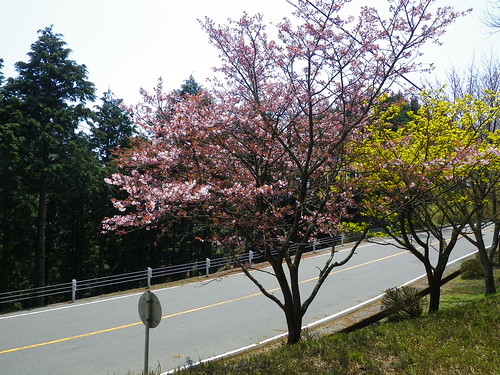
Sadly, the trail began to parrellel the road. The sakura were still nice however.
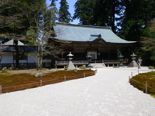
Here things get a little odd, as civiliztion picks up the trail becomes harder to discern. It dumps you out in parking lots and diverts under roads and through temple grounds. Here is, I believe, part of Enryaku-ji. You can make a guess as to which building because I have found that I can do hiking or temple viewing, but I can't make the two mesh. I just want to get through the temple and back to the trail. It isn't so much the temple as that I emerge sweaty and muddy into a bunch of men in polo shirts and women in high-heels and I feel like I am a fish jumped into someone's canoe. Disconcerting.


From here the trail gets really odd and I got lost for about 30 mintues. This seems strange as this is the most well traveled are I passed through. Exactly. I choose the path that looked like a trail and ended up at a dead end in the woods, when I should have taken the main toursit path towards the cable car. I encoutnered other hikers staring at signs and turning their maps murmuring, "Yayakoshi." While their spouses nodded knowingly. Fortunately I had only myself to apoligize to and I continued on the tourist path with its large stone staircases.
It was in following this path that I ran across Jodo-in. This I almost walked past in my haste, but I know a little bit about it and was drawn back by its purpose and very real beauty.

If anything it was its accesiabiltiy that made me back away and almost not enter. It is almost too open. After considering I passed through the wooden gate to the simple garden. The Jodo-in houses the grave of Saicho (Dengyo Daishi), the founder of Enryakuji. The mnks who tend his grave pledge to not leave the mountain for a period of twelve years. Maybe that can make you understand why I feel a toll road cheapens the place a bit.
From here the trail and the unpaved tourist road towardsw the cable car are the same path. There is one fork in the road where one can go left to Shiga or right to Kyoto. To the right the trees clear out and there is amazing views of Kyoto with sakura still present.


It really is almost unbearably lovely and one wonders if it looked like this in 1571 when Nobunaga unleashed his armied on the monks and slaughtered a reported 25,000 and burned everything down. There are some sections of the woods that have the damp, heavy feel of the killing fields of the American Civil War. Mechanicsville comes to mind.
Just past these impressive views is an odd ghost town of a ski complex that looks like something out of Scooby-Doo. The mountain would be better without and I would be better with photographs. Just imagine an abandoned arcade. The grassy slope had several people lounging on it reading books, so it can't be all bad.
From here the trail continues down the main path to the cable car station.
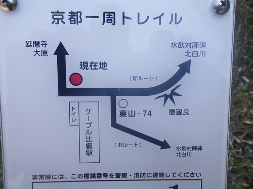
If anyone knows what the kanji proceeding "Shirakawa" are, please inform me. I thought that maybe it meant that one couldn't drink the water, but now I think not. The cable car is the usual Japanese conglomeration of stinky toilets and vending machines. A man with a tracheotomy tried to figure out how to use the 100 yen viewfinder. The trail diverts into new trail and old trail. I was just looking to stick with it until marker 69 where two other trails diverted off down Shirakawa to Shugakuin. From this juncture there is one last view of the city.
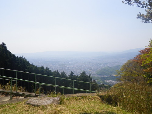
From marker 69 there is a great moment where you can here the roar of water from a fall in Shirakawa. The trail down is standard Japanese mountain trail. You end up in a very narrow and steep gully, looking for snakes in your hand holds. The trail is so steep that sometimes you can look up out of the gull and realize you are gazing down at the city. Can you picture what I mean? Another great aspect is that in some stretches you are looking down on Daimonji, which is an odd experience and feels almost unsettling when you realize that that is what you are looking at. It is about a two hour hike down this steep fern-gully. Unfortunately the back of Shugakuin is secured by concrete and barbed wire, so the hike doesn't feel as natural as it could. A further issue was a huge group coming up the mountain. There were at least 30 people in the party. If you hike in Japan, you know what this means; I had to give a genki "Konnichiwa" to every last member. That was more tiring than the decent. The trail ends up in a quiet neghborhood with a park next to the river. The road runs steeply downhill towards Kitayama and the train station. I found this bumbersticker that may only be humorous to me.

I had planned on walking the river back to my house, but my foot was hurting and I was out of water so I got on the train and set next to an attractive lady without thinking about how I smelled. It is a 200 yen ride back to Demachiyanagi. Of course you can do this hike in revere and take the bus back from Ohara. I think I might try going straight over the mountain and out the back to Sakamoto this weekened.
2 comments:
I am infinitely jealous. Maybe not of the death piggy, but the other stuff. I've hiked nearly every trail around here. I miss the new trails and the sense of freedom and adventure that comes with them. I would go back to them but with my mom in nursing school and my friends whiny I don't know how that'd work. Maybe when Ma finally has some free time.
click for source i7m75m4p24 gucci replica replica nappy bags Homepage v3e31w1s38 replica louis vuitton bags replica bags london resource k2z32q7v02 replica designer backpacks replica bags paypal accepted
Post a Comment